Wednesday, July 16, 2014

Do landslides happen around your own corner?

Saturday morning, March 22, 2014
Deadly landslide happened in ... no, not in China or India, ... in Oso, Washington, USA.

42 people died. One is still missing.


What happened in Oso, WA so recently?

50 miles north of Seattle on a Saturday morning on the 22nd of March, 10 million cubic yards of debris came down a slope. The landslide had a velocity of 60 miles/hour! There was no chance of running away. 45 houses were destroyed. The total damage amounts in millions of US Dollars. At the very same location in Oso, landslides happened in 1951, 1967, 1988, and 2006. None as devastating as the most recent one. The ground was fluidized due to heavy rainfall and slid as a mass of mud downwards.
End of May, after the completion of the mudslide debris removal, the State Route 530 reopened again. But there is still a lot to clean up... 

See here for maps of the affected area.


Slide Area of Oso Landslide, Washington State, March 2014


Landslides happen more often than you think, and they may occur just where you live!


What is a landslide?

A landslide is a downward falling or sliding of a mass of mud, soil, detritus, or rock on a steep slope.


Where does a landslide may occur?
  • One way to figure out where landslides may occur, is to look at ancient landslides. Ancient landslides may reactivate.
  • Another point is existing rivers or streams. Rivers tend to bend from left to right to left to go their way down to the ocean. The water of a river is faster on the outside of a curve than on the inside, which could lead to elutions or scours of adjacent land on the outside. When the foot of a slope is missing, the slope may get unstable and slides downwards.
  • A third - and may be by homeowners unpopular - point is the clearing of steep slopes from high trees. A homeowner may want to have a marvelous view over the valley, but the same slope is stolen the roots. Roots of trees and bushes stabilize a slope and transport water from the ground into the air. In case of heavy rainfall, a slope without its stabilization is meant to slide.
  • Another point to look at is water pipes and drainage lines. Water should be collected above a slope. Concentrated water outlets, e.g. from a street above a slope, over time may be a trigger and the slope may get washed away. 
  • Broken water or sewer lines may be a trigger, too. The water flows concentrated down the slope and may weaken it. To counteract, every water pipe in the ground should be tested in spring time to make sure it is not broken.

What questions should be asked in case of a landslide?
  1. Why did it occur?
  2. How to mitigate immediately?
  3. Is the rest going down, too?

How to control a landslide?
  • Water collection! The collection and transfer of any kind of water is a critical point.
  • Vegetation of a slope! The roots of vegetation hold the slope itself and water is taken from the ground into the air.
  • Ancient landslides? A reactivation of an ancient landslide may occur. Mapping of "inventory" and susceptibilities are necessary to analyze ancient landslides.


The most recent landslide in the US:

The most recent landslide is still sliding. It is in Fort Washington, Maryland. The slow downward movement of the land mass cuts off water, sewer, and electricity lines, which affects 28 homes and their residents.


(I thank Dr. Scott Burns - Prof. of Geology at Portland State University and GIGSO - Oregon State University Geo-Institute Graduate Student Organization for the guest lecture about landslides at Oregon State University on May 28, 2014.)

Sunday, June 15, 2014

Bonneville Lock & Dam

The stunning beauty of the Columbia River took me into another world. To hike in the Mt. Hood region of Oregon, and to see Triple Falls was inspiring and relaxing at the same time.

At the same place, some 76 years ago, in 1938 the Bonneville Lock & Dam was built.

I walked into this dam on the Washington shore wanting to see jumping salmon. So, I was standing there, looking down on the water and waiting to see fish jump. Well, they didn't jump, at least not here.


Stephanie Lange and Ryan Braaten
But something better happened. Park ranger Ryan Braaten came by and asked if I wanted to see the salmon. Yes! He took me below into a big room which looked like an aquarium. The dam consists of a fish observatory including fish counting which is constructed in this manner that the visitor can see the traveling fish under water. And there were so many of them! Ryan explained everything about salmon, hatchery, wild ones, chinooks, and so on. In a little dark corner, shielded from the visitor room, sits one person counting every fish. The counting of the fish goes into how much salmon is there, how much wild ones are there, and how much is allowed to be caught. It is not allowed to catch real wild salmon. When a restaurants menu says "wild salmon" it is probably from a hatchery.


What was even more exciting than to see the salmons was the fact that Ryan gave a short tour around the dam itself. The Bonneville Dam is one of 14 dams of the Columbia River. It was built to improve the river navigation and to generate hydropower for the Pacific Northwest and parts of California. To react to the rising need for energy, a second powerhouse was built in 1981. Ryan showed the turbine cavern with 8 hugh power generators. This cavern was so impressively big, the workers looked like little ants next to the mammoth machinery. Thanks to Ryan, we walked onto a generator, looked into it from above to see the copper coils and the rotating Kaplan turbine. To see these energy generator in reality is impressive and I suggest to everyone to see it at least once to get an idea what kind of effort has to be taken to produce all the electric energy we use in our everyday life.

Thanks to Ryan Braaten, who loves to bring specific objectives and themes closer to visitors and audiences and explains it in a way everybody understands - from accountant to geotechnical Engineer. No wonder he received the U.S. Army Corps of Engineers' highest agency national award for interpretation in 2013 - Hiram M. Chittenden Award for Excellence in Interpretation.

Thursday, June 5, 2014

2014 Geotechnical Symposium at UW - Student Research

The Geotechnical Symposium at the University of Washington (UW) in Seattle was a successful event to connect and exchange research done by graduate students in the Pacific North West (PNW).


Lisa Dunham
Lisa Dunham, PhD student at University of Washington:
The goal of her research is to map possible landslides along roads in Alaska. This map could be the basis for future risk management and road improvements. In her research, she combines geomatic analysis using LiDAR with geological features and a risk analysis to determine relative risks alongside Alaska's roads. Her findings are going to be visualized in form of a map. 
The work is a cooperation of the University of Alaska, Oregon State University, University of Washington, PacTrans, and Alaska Department of Transportation & Pubic Facilities.


Michael Huber
Michael Huber, master student at University of British Columbia in Canada:
District heating is used to transport hot water or to heat/cool public buildings. Thermal expansion of the pipes and the soil-pipe interactions must be taken into account. Michael's research project analyzes soil-pipe interactions of district heating pipes and investigates different methods to handle the stress of the pipes due to thermal expansion by building lyres and low-loss pipe connections.


Panel Discussion
The Symposium ended with a panel discussion about education at universities in the PNW. Questions about the structure of education were asked between students of each school to discuss similarities, differences and possible improvements.
To summarize all, most of the universities have similar education structures from the length of study, use of laboratory equipment, type of classes like Geology, Seismology, Hydrology, Foundations, Soil Mechanics ... , and student associations, who invite guests from the industry every week or month to give lectures. The education at all universities mainly contributes to the field of research.


"Wish-List"
From student's perspective, some points were mentioned, which could improve the education at the universities in the PNW. Let's say, it is the “wish list” of the students: 

  • Introductory classes in rock mechanics,
  • Classes about presentation techniques and report writing,
  • Complete case studies throughout an academical term or year, and 
  • More hands-on experience outside the class room in form of field trips.


I hope the Geotechnical Symposium in the PNW is going to happen again in the near future. It is a great opportunity to present ones research objectives, exchange ideas and - most importantly - make connections for future work.

Sunday, May 25, 2014

2014 Geotechnical Symposium at UW

It had been twenty years since a Geotechnical Symposium for graduate students from universities in the Pacific North-West (PNW) was last organized.

The University of Washington (UW) was the host for the symposium 2014, which took place between the 8th and the 10th of May. The purpose was an exchange of ideas, research findings, and to professionally connect with other students and professors. The event consisted of a lecture and reception on Thursday evening, a whole day of presentations and poster sessions on Friday, and a field trip on Saturday to explore geohazards.

In this post, I am going to give some detailed information about the field trip itself. And in my next post, I will provide some detailed information about student research.

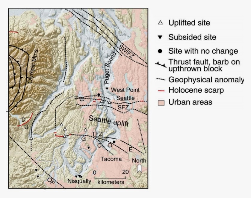
On Saturday, our group went to a field trip to the surrounding area of Seattle, WA to explore geohazards in the Seattle Fault Zone (SFZ). During our field trip, we listened to Thomas Doe, our geology guide for this day.

Craig Weaver and Brian Sherrod, USGS, Sound Shake '08

The Seattle Fault Zone is one of a series of major faults that cut across the Puget Sound basin. During an earthquake in 900-930 A.D., the Seattle Uplift occurred and resulted in an uplift of up to 9 yards or 8 meters. During our field trip we were able to stand exactly on top of the northern line of the uplift on a parking lot of the Eastside Christian Community Church. The whole uplifted area is indicated in the picture above. The field trip went on to Lake Sammamish east of Seattle, where the same earthquake, which caused the uplift, caused a still visible landslide.

Finally, we finished our tour at Cougar Mountain Regional Wildland Park. This park has a rich coal mining history. At first, we hiked on beautiful trails and over creeks to get to closed entrances to old coal mines. We discussed the hard work at first with mules, later with rails and oil lamps back in old times, and looked at the provided pictures on-site. The coal mining started in 1863 and went for 100 years. The mine worker tunneled up to 6 miles under the mountain to get the coal, which was then transported with Seattle's first railroad to a harbor and shipped to San Francisco. Most mines are multi-story, like underground apartment complex, leaving the ground above unstable and susceptible to sinkholes. Nowadays, the park is full of green leaves, trees, beautiful creeks, waterfalls and wild animals - nature took it back completely. But at the time of the coal mining, this same area was a big city of more than 600 homes, a rail line, hotels, stores, and churches. While hiking on trails through the forrest, one can still find pieces of coal, the mountain is made off.
Besides the historical importance of this huge park, for me, it is an astonishing beautiful landscape to hike.

The field trip ended with "goodbye's" and "hopefully till next year" comments and expressions. The success of this symposium could most likely result into an annual repetition of meetings in the PNW.


In my next post, I am going to give some detailed information about research of two graduate students and in addition, I will give an overview of results of the panel discussion about education at universities in the PNW.

Friday, May 16, 2014

Launch Post, the Second

Dear reader, welcome back to my blog.

After a year of silence, I am writing to you again.

A lot happened, not only in the world of underground structures, also in my personal life. I moved from Switzerland to Oregon, U.S.A. to pursue a PhD study in the field of geotechnical and earthquake engineering at the Oregon State University. More about how to apply for American universities, how to put yourself ahead in front of the all the other applicants, how to get to be known by well known professors, how to successfully get accepted at the universities of your choice, and other related topics like how to find a research topic for a PhD ..., more about all this in my upcoming articles later on.

But first, in my next posts, I am going to talk about the most recent events:
  • The Geotechnical Symposium at University of Washington (UW) in Seattle, WA, U.S.
  • Some intell about the Bonneville Dam and the Columbia River
  • Floating bridges in Seattle
  • A recently happened land slide in Oso, WA
  • The next upcoming event - the 10th U.S. National Conference on Earthquake Engineering in Anchorage, Alaska, in July - is getting some attention and posts from me, too.

I intend to post new articles every 10 to 14 days.

Forecast:
  • May 25th - General information about the Geotechnical Symposium at UW
  • June 5th - Presented topics at the Geotechnical Symposium at UW
  • June 15th - Bonneville Dam

I hope I got your interest in my next posts.

If there are topics you would like covered or if you are interested in special themes of the National Conference on Earthquake Engineering, who I should see, visit or talk to, please let me know in the comments.


Have fun reading and discovering my blog.

Stephie